simond
Western Thunderer
Maybe so, but whether it’s retaining the land from becoming mud, or the mud from becoming land is clear as, well…it becomes clear that it was some kind of retaining wall.
Maybe so, but whether it’s retaining the land from becoming mud, or the mud from becoming land is clear as, well…it becomes clear that it was some kind of retaining wall.


I'm assuming that the river will remain much more stable from now on with it being so well used; there are retaining walls on a lot of the southern bank now but it still retains that slightly shambolic atmosphere.
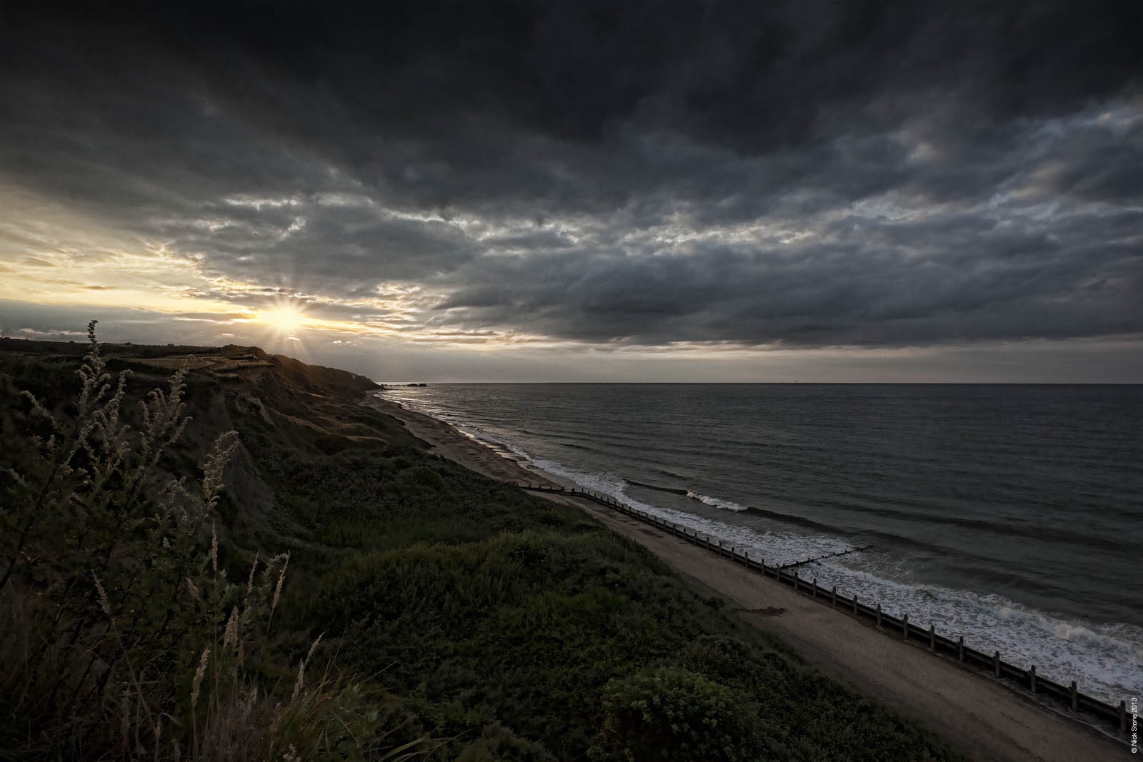
That coach looks like GER type 3b pre 1885 stock... Most likely a 3rd due to the close nature of the compartments... Would need a full side on view to work out the diagram but would either be a 402 (4w five compartment 3rd) or 403 (6w six compartment 3rd)Thanks for that bit of research Dave, it's very informative - and fascinating. Apart from the erosion along the coast it's interesting to see how the deposit has built up on the south side of the estuary and effectively moved that part northwards. I can't wait to get back there and do some more research, and it's tempting to chuck the tent in the car and just set off. It'll have to wait for a bit though as family commitments make it impossible right now - September perhaps.
I'm assuming that the river will remain much more stable from now on with it being so well used; there are retaining walls on a lot of the southern bank now but it still retains that slightly shambolic atmosphere.
View attachment 219973
View attachment 219974
View attachment 219975
Sssshhhhh.... You might give the game away.....Is it me or is there is an element of irony in that Western Thunder is currently hosting what I would describe as a significant amount of interest in things East Anglian/ Great Easterny..........


Being in Australia i had to chuckle when i saw the aerial photos as i was walking around there about ten months ago watching the ferry lady putter back and forth and wondering how long it would take for the pebble beach to become a sandy one .When you look at the NLS OS 1892-1914 25 inch series and change the overlay transaparency in respect of the underlying satellite imagery you can see how 100 years+ coastal erosion and intervention has changed the area. I've annotated two NLS extracts to show this.
View attachment 219887
And a zoomed out version of the coastline. Red being 1892-1914 and yellow from today's satellite imagery.
View attachment 219886


Hi Rob,
I can't take credit for the design. I drive up to Richard's (Heard) on Tyneside where he has a workshop with some delicious tools. At home I get by with a saw and set square! He has developed this method and we used it for Old Parrock.
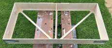
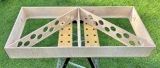
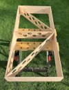
Basically, we cut a piece of 6mm birch ply the dimensions of the board and this becomes the bottom. We then cut out everything to leave a web of the frame. The ends are 9mm birch ply and we set the board joints in first. The diagonal cross pieces have holes cut in to reduce weight and the whole lot is then glued and clamped in one go - clamping is very important and Richard owns more clamps than a heart surgeon.
The next morning the whole thing is strong and stiff with absolutely no twist - it's a glorious moment. It's also light which is important because my boards are already beginning to accumulate weight with all the added extras.
We reckon that it would work with 4mm birch ply but I'd still use 9mm at the ends.
View attachment 220448
I cannot recommend highly enough the period after all the holidaymakers have gone home, despite the cooler temperature..... I can't wait to get back there and do some more research, and it's tempting to chuck the tent in the car and just set off. It'll have to wait for a bit though as family commitments make it impossible right now - September perhaps.
Hello Nick,That’s a very interesting way of building boards - it’s quite similar to an aircraft wing in a way! Could you take some photos of over angles and joins. I have a small project which requires a few more boards and I’d be interested in adapting this idea.
Clamps do make the world of difference. I own several long sash clamps, and 40 odd 6-inch F ones. They really do make life easier. That coupled with a table saw, pillar drill and a good, large flat surface is key in my experience.
All the best,
Thank you, Richard, that’s really useful to see.Hello Nick,
Here are three photos of Paul's baseboards under construction - I'm afraid that these are the only photos that show the joints. You'll probably be able to make out that the joints are not sophisticated, but are simple butt joints, which were clamped and glued in stages. I must emphasise that I have no engineering background or knowledge, so this design and approach only emerged intuitively and pragmatically. However here's my explanation of the construction:
The one-piece fret that forms the bottom of the structure keeps the bottom edge of all the sides, ends and diagonal cross-members in alignment, and gives stability and reinforcement at the bottom of each vertical joint. The combination of square and diagonal members glued at all contact surfaces gives rigidity in all directions to prevent twist, especially when the trackbed is attached. Essentially the bottom fret, the vertical members, and then the trackbed on the top combine to form a strong 'box' of interconnected I-girders. The trackbed or top surface board will be screwed in place but not glued, to allow for possible future modifications and/or re-use. The bottom fret and the positions of the various joints can be arranged to meet the needs of the layout design - they don't have to be completely regular, but what matters, I think, is that (a) all the joints are cut to give a firm fit, and (b) the diagonals running in opposing directions are critical in ensuring overall rigidity.
I hope this helps,
Richard